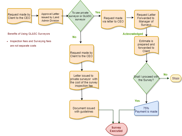
The approval letter issued by the Land Administration Division would indicate whether or not the individual or entity has the option of soliciting the services of a Private Surveyor or utilizing the services of the Commission to have the survey executed. If the choice is to use the services of the Commission, then the request is made in writing to the Commissioner of Guyana Lands and Surveys Commission. The Commissioner then forwards this request to the Manager of Surveys or the Senior Surveyor. The Request is acknowledged and an estimate is prepared and forwarded to the individual or entity. Provided that a decision is made to proceed with the survey, a payment is made in full of 75% of the cost is payable before commencement of the survey and the remainder to be paid before the lease is uplifted.
The Manager of Surveys or the Senior Surveyor identifies a GL&SC Surveyor to execute the survey, once the requested monies are paid. In the case where the services of a Private Surveyor is solicited, a request is made by both the person and entity requesting the survey to the Commissioner for Permission to Survey. These requests must be accompanied by a copy of the Approval Letter and a sketch depicting the area to be surveyed. Provided that the application for Permission to Survey is acceptable, a letter is then issued to the Surveyor outlining the cost for the survey inspection fees. These fees are charged by the Commission to ensure that there is a proper quality control for the execution of the survey and that due process is followed. Once these fees are paid, another document is issued giving permission for the survey to be done which outlines the procedures and requirements for the survey to be executed. After the survey would have been completed, a Cadastral plan is submitted to the Commission by the Surveyor showing the area which would have been surveyed. This plan is then checked, approved, and the original is issued to the Surveyor, and the certified copy of the original is stored in the vault.

Flowchart Depicting Elements of the Process

Key Services Offered
Cadastral Survey
This type of survey for state and government lands are executed by the Cadastral Section of the Surveys Division of the Commission. These surveys define the limits of the lands surveyed and the final product is a cadastral survey plan. The titling may be for leasehold or freehold purposes. these surveys also define the limits of Amerindian Grant Title Lands in order that an indefeasible Certificate of Title can be issued. The Commission may also survey private property at the request of the Courts.Please find price list below containing the various costs for processing mutation forms & surveyors Report.
Engineering Survey
These surveys are executed by the Geodetic Section on major government projects. Depending on the extent of the survey, some geodetic controls may be necessary. These surveys are associated with setting out engineering design and layout.
Topographic Survey
Topographic Surveys are executed by the Geodetic Section to determine the topography of the terrain for major Government projects. Depending on the extent of the survey some geodetic controls may be necessary. These surveys gather data for engineering designs.
Occupational Survey
Occupation surveys are done at the request of the Courts to show what is located where. That is, where fixtures are located relative to other fixtures. The surveys also provide information on the occupation and occupants of the surveyed area.
Additional Services Offered
Recording of Plans
This is a service provided by GL&SC to sworn land surveyors. The issuing of Titles (Grants, State/Government Leases, Transports, Certificate of Title, 999Leases), Court Order Surveys, Re-Survey of Boundaries and Sub-Division of Lands all require a recorded surveyed plan. For legal transactions to take place such as an Agreement of Sale, Deed of Gift and Prescriptive Title Survey, the survey plan showing the portions of lands surveyed has to be registered at GL&SC for a fee payable by the surveyor. The fee ranges from $4,000 to $25,000 dollars. That is the minimum fee for one to four lots is $4,000 and the maximum fee for 100 lots and over is $25,000. Please find price list below containing the various costs for recording survey plan, prints of survey plans and prints of map sheets
Price ListCertified Copies of Plans
Certified copies and prints are costed based on the size and the amount of colour and features that have to be reproduced. Certified copies are done on miler film while certified prints are done on plotting paper. Clients are provided with a quotation of cost of the certification of prints and plans on request. The Surveys Division produces sketched and compiled plans at the request of Real Estate Agents, Property Owners, Property Developers, General Public, Government Agencies and the Private Sector and the cost for providing either sketch plans or compiled plans is based on the volume of work involved, the man-hours employed and the amount of material used for the final drafting. Please find price list below containing the various costs for Registering and Processing Survey Plans with 10 Traverse Legs and above.
Price ListSupply of geodetic Data
The Survey Section charges a fee for Guyana Lands & Survey Commission's Geodetic Data. The sale of both horizontal and vertical control data and their descriptions is seven thousand five hundred dollars ($7,500). This data is mainly requested by surveyors -in the private sector, engineers and consultants. This data is also available for the general public.
Certified Copies of Plans
Certified copies and prints are costed based on the size and the amount of colour and features that have to be reproduced. Certified copies are done on miler film while certified prints are done on plotting paper. Clients are provided with a quotation of cost of the certification of prints and plans on request. The Surveys Division produces sketched and compiled plans at the request of Real Estate Agents, Property Owners, Property Developers, General Public, Government Agencies and the Private Sector and the cost for providing either sketch plans or compiled plans is based on the volume of work involved, the man-hours employed and the amount of material used for the final drafting. Please find price list below containing the various costs for Registering and Processing Survey Plans with 10 Traverse Legs and above.
No. | First Name | Last Name | Initials | Date of Oath | Status |
|---|---|---|---|---|---|
No records to display | |||||